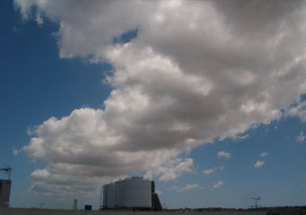
Above: Cumulus Tuba
Cumulus Tuba
Cumulus tuba clouds are those white clouds seen on sunny days and usually against the blue sky. This heap of cloud has a flat basis that is seen in the middle and its vertical development produces a tower-like or even a cauliflower's shape. The cumulus tuba clouds are formed through convection when air that is warmer than the surrounding rises and as it rises; its temperature reaches the dew-point which causes some water to condense out of the air hence forming the clouds. In fact, the clouds do extend a finger like shape towards the earth.
What height are the cumulus tuba clouds found?
The amount of atmospheric moisture is the sole determinant of the height these clouds will form at. The lower cloud base for instance, results from humid air and the base may go up to 2400 meters in altitude when in temperate areas. The mountainous and arid areas can have in excess of 6000 meters as the clouds’ base. It is worth noting that not all cumulus clouds can create cyclones even though at the heights of over 3000 meters and in windy conditions, cyclone’s occurrence is possible.
Classification of cumulus tuba clouds
There are two basic types that these clouds are classified by and these are stratiform and cumuliform. Types
- Cumuliform, a Latin word which means a heap of the clouds, is a classification of puffy clouds which occur as a result of orographic lifting or convection. Such puffy clouds are referred to as cumiliform clouds.
- Stratiform is also derived from the Latin word stratus, which means a layer. These are flat and layered clouds and are mostly seen during stable weather.
The above types can be classified further depending on the height of the cloud base. They are therefore classified into
- Cirrus clouds: These are clouds whose heights are always above 16,500 feet.
- Cirro: This prefix denotes cumulus clouds whose heights are classified as high-level.
- Alto: Such a prefix denotes the clouds in the range of 6500 feet to 16500 feet of height.
How are cumulus tuba clouds formed?
Convection is the process that causes the formation of these clouds. During this process, warm and moist air rises and later cools until its temperature matches that of dew-point and water vapor will then condense developing solid crystals or liquid cloud droplets. The lapse at which the air cools as it rises is rated at 100c per kilometer.
What do cumulus tuba clouds look like?
They are puffy white looking clouds with the shapes almost similar to the common towers or even cauliflower and are visible during sunny days when the sky is blue.
How common are cumulus tuba clouds?
These clouds are most common during autumn and spring as they will form during such unstable and heavy current weather conditions. Sometimes it is possible to have these clouds during the summer due to the changing weather conditions.
Where can I see cumulus tuba clouds?
It is possible to observe these clouds in Central America, the Pacific Coast of Japan and the Pacific Coast of the United States of America. The cumulus congestus clouds are however visible in almost all parts of the world.
