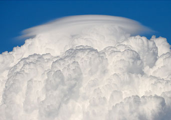
Above: Cumulus Pileus
Cumulus Pileus
The tag of this cloud formation may be somewhat misleading regarding its nature, as it basically conveys that the cumulus pileus is just another division of the extensive cumulus category. However, a more accurate description of the cumulus pileus would deem it the buffer between cumulus or cumulonimbus formations and their higher elevation counterparts. It is well known that cumulus formations have a tendency of evolving into other types of clouds, commonly in cumulonimbus rain clouds. Therefore, it is easy to understand the motives of associating the cumulus pileus with impending thunderstorms and generally unsteady weather.
What are cumulus pileus clouds?
In essence, the cumulus pileus are the extra air mass that rises on top of other clouds, but their lifespan is rather limited. During the convection, which is the process responsible for the formation of most clouds, certain air masses are elevated beyond the saturation point. In order to understand what the distance associated with the saturation point is, it is important to mention that the temperature of the rising air mass loses approximately ten degrees for every one thousand meters. Therefore, since the cumulus pileus formations exceed the saturation point, their makeup will generally incorporate ice crystals.
What height are cumulus pileus clouds found?
Due to the nature of their process and particularly the fact that the cumulus pileus is not a stand-alone cloud but rather an appendage of cumulus or cumulonimbus formations, the upper section of any water-rich formation is their most common location. More exactly, based on the general elevation of the aforementioned clouds, the expected altitude for pileus is generally 6.500 feet above the sea level.
How are cumulus pileus clouds formed?
The cumulus pileus clouds are born through what is essentially a high-speed convection process compared to the rate at which the other cloud formations are generated. The augmented rate of the convection can be explained by the significantly reduced warmth of the troposphere section, which helps the air masses chill more rapidly.
How do cumulus pileus clouds look like?
During the formation process, the shape of the cumulus pileus clouds will somewhat resemble an erupting volcano. However, the most common forms associated with them a few minutes later are generally mushroom caps or anvils. Their texture appears silky when observed from the ground and are often being described in the same manner as clouds proprietary to mountain peaks. It is important to note, however, that while the clouds located around the mountain crests rarely change their position or their overall shape, the lifespan of the cumulus pileus will rarely exceed a couple of minutes
How common are cumulus pileus clouds?
The conditions that are appropriate for the formation of the cumulus pileus clouds is also an indicator of how often they can be seen. More exactly, wherever the meteorological conditions enable the birth of cumulonimbus or cumulus clouds (conditions for convection), the cumulus pileus formations are to be expected. However, the zone in which the cumulus pileus clouds will never come into existence are:
- South Pole
- North Pole
