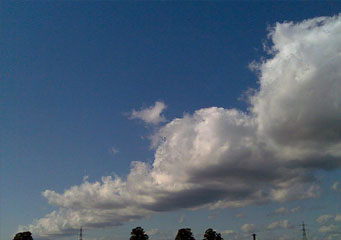
Above: Cumulus Radiatus
Cumulus Radiatus
Since clouds are commonly formed when the warm air from ground level rises up to meet the cold air in the stratosphere, there are many variations that can take place and this explains the numerous types of cloud formations. The water vapor rises up from the ground and meets the water droplets or ice crystals and this will result in condensation which is visible in the form of clouds. Cumulus radiatus clouds are a part of the family or genus of cumulus clouds and the levels of humidity in the air are the determinant factor in the formation of such clouds.
What height are cumulus radiatus clouds found?
Cumulus radiatus clouds commonly form at lower levels from about 6,000 feet although on occasion it can move higher up to heights of about 10,000 feet. The factors that determine this are:
- The levels of humidity in the air rising up from the ground
- The amount of water droplets or ice crystals in the sky
- The type of winds that may be present
Classification of cumulus radiatus clouds
Cumulus radiatus clouds are also known as cloud streets because they appear to form as parallel lines that run across the sky – this distinct visual feature is probably the best way to differentiate between this type and the others. There is no specific classification within the cumulus radiatus family as this is a specific type of cloud formation of its own.
How are cumulus radiatus clouds formed?
Like most clouds from the cumulus genus, the cumulus radiatus clouds are formed based on the levels of humidity in the air. However the cumulus radiatus clouds are known as cloud streets because in the process of their formation, and depending on specific wind conditions, it is possible to see a continuous roll or row of cumulus radiatus clouds forming a street or even parallel streets in the sky. Cumulus radiatus clouds are usually formed when the warm and humid ground air rises up to meet the cooler air in the stratosphere.
What do cumulus radiatus clouds look like?
Literally forming parallel lines in the sky, the cumulus radiatus clouds are considered to be a unique formation of clouds within the cumulus genus or family. Clearly visible, they sometimes look like a roll of waves washing into the shore and depending on the precipitation, can either be a clear fluffy white or a dull grey. When it is grey there is a higher chance of it bringing rain.
How common are cumulus radiatus clouds?
Cumulus radiatus clouds are less common as there are specific temperature conditions and wind conditions that must be achieved in order for this cloud formation to be created.
Where can I see cumulus radiatus clouds?
Cumulus radiatus clouds are visible mostly during the summer months and also along the coast. This is because the winds at sea move at a faster rate and where there is an accumulation of cumulus clouds, the wind can influence how these clouds are formed. The cumulus radiatus clouds are also a common formation in tropical countries and more often visible there.
