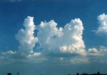
Above: Cumulus Congestus
Cumulus Congestus
Cumulus congestus are also known as towering cumulus. They usually have pronounced vertical developments and sharp outline. Sometimes this cloud formation may appear as tower like clouds which appear to also have cauliflower aspects such as the shape of the cauliflower head. This cloud formation can indicate rays of the sun, referred to as crepuscular rays, when the sky is a bit obscured and it also scatters the sunlight.
What height are cumulus congestus clouds found?
The congestus clouds also known as the towering cumulus can be found in the low and middle height ranges. They are based in unstable regions of the atmosphere where convection is taking place. The clouds usually appear taller and they can go up to a height of 6 kilometres equal to 20,000 ft. In the tropics, the height of the congestus goes higher than 6 kilometres. Due to the fact that the congestus cloud formation usually comes about as a result of strong updrafts, they tend to be taller than they are wide.
Classification of cumulus congestus clouds
Below are the major classifications of the congestus clouds
- Cumulonimbus clouds: The cumulonimbus clouds are in a group of clouds usually referred to as thunderstorm clouds. They are also known to bring about heavy rains, lightning, hail, snow and even tornadoes. The cumulonimbus clouds resulting from congestus clouds can go up to a height of 10 kilometres. Due to the high height, the high winds flatten the cloud’s top making it to have an anvil like appearance.
- Cumulus congestus: These are large clouds whose bases are flat and grey in color. They are also tower like formations.
How are cumulus congestus clouds formed?
The congestus clouds are formed as a result of water vapor condensation from the earth’s surface. The air currents are strongly condensed upwardly from the surface of the earth. This cloud formation has a vertical depth that appears greater than its width therefore for it to form the earth’s atmosphere is required to have an unstable layer than the one that is required in order for the cloud formation to take place. When the wind speed increases because of altitude it causes the cloud formation to tilt.
What do cumulus congestus clouds look like?
The congestus clouds have sharp outlines and also appear vertical. In appearance the clouds may look like floating cotton, the top of the congestus cloud will take the shape of a cauliflower head.
How common are cumulus congestus clouds?
The towering clouds also referred to as the congestus clouds are usually common during summer and may be accompanied in some occasions by light rains. In some places the cumulus may result into heavy rainfall. Usually when this cloud formation appears during the morning hours it may be an indication that a storm is likely to take place later on as the day progresses. The congestus may also transform into cumulonimbus if it starts to forms ice.
Where can I see cumulus congestus clouds?
This cloud formation can be seen anywhere around the world and most common for regions that experience summer.
