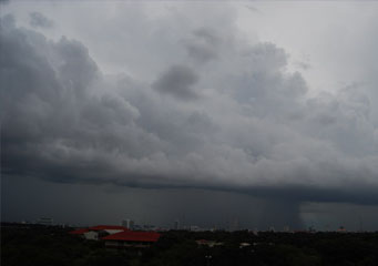
Above: Cumulus Praecipitatio
Cumulus Praecipitatio
Under normal conditions, the clouds that are included in the cumulus category are rarely responsible for producing any kind of precipitation. However, when the cumulus overloads with moisture particles so much that it's mass cannot be supported, that is the moment when the cumulus praecipitatio clouds can form. It is important to note that this specific type of cumulus cloud will produce precipitation that will reach the ground. In addition, the rain resulted from a cumulus cloud will vary from very light to heavy, as the air from the cloud lifts higher into the atmosphere.
How are cumulus praecipitatio clouds formed?
In general, the warmer mass of air is able to support a higher amount of water vapors that tend to rise higher into the atmosphere. While all hot air that rises will cool down and take the shape of water droplets, the only condition when it causes precipitation is when they combine. The reason for this is that they get heavy to the point that their weight can no longer be supported.
On a side note, the amount of precipitation they can produce is usually dependant on the speed of the cloud, the overall size of the inferior area of the praecipitatio as well as whether it has the necessary conditions to continue to expand or not. If all the aforementioned prerequisites are met, then there is a chance for the praecipitatio cloud to transform into a thunderstorm cloud.
How do cumulus praecipitatio clouds look like?
Unlike other types of cumulus clouds, the praecipitatio tends to get flatter and darker as it accumulates more combined water particles. The shades of grey that the cloud has at its base as well as its dimensions are indicators of whether the cloud will be accompanied by a mere shower like rain or heavy, cascade precipitation that last a bit longer. The main difference between the appearance of this cloud and other rain clouds resides in the fact that it tends to have a lighter tone in the upper part.
What height are the cumulus praecipitatio clouds found?
Usually, the clouds that are responsible for rainfall are formed in the higher parts of the atmosphere where the conditions are unstable. Because they are heavier due to moisture accumulation, they are regularly noticed as dark clouds under other types of cumulus formations. All in all, they are usually situated around two thousand meters above sea level.
How common are cumulus praecipitatio clouds?
Due to their mechanism of formation, one should expect to see praecipitatio cloud materialize in climates that have a high humidity in the air or that are extremely warm. It is important to note that even though they can appear in the aforesaid environment that does not mean that the cold climates do not have the necessary conditions for the materialization of these clouds. Therefore, here is a list of the most common precipitation that can fall down from praecipitatio clouds:
- Rain
- Drizzle
- Snow
- Hail
- Ice grains
