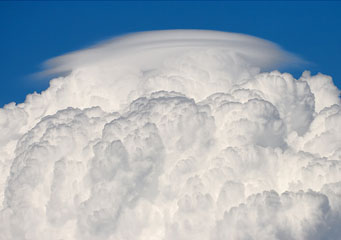
Above: Cumulus Pileus
Cumulus Pileus
Even though its name may indicate the fact that this type of cloud is part of the extended cumulus family, it is important to note that they develop as top-over cumulonimbus clouds or cumulus clouds. Because the cumulus clouds can develop into other formations, especially the cumulonimbus rain clouds according to the humidity of the air found in that part of the Earth, the pileus clouds are usually a clear indicator of thunderstorms and unstable weather conditions.
What are cumulus pileus clouds?
The pileus clouds are small masses of air that can be noticed above other cloud formations for short periods of time. To put it simply, they form when the air is being pushed upwards in the higher parts of the atmosphere, but they tend to lose their cap shape in just a few minutes. Because they usually pass the zone where meteorologists set the maximum convection point of all clouds, also known as saturation, the composition usually includes fine ice crystals.
What height are cumulus pileus clouds found?
It is important to note that the pileus do not form independently, but rather require a preexisting type of cloud that contains a high water vapor concentration. Therefore, if convection still occurs in the upper side of the cumulonimbus and more seldom onto the cumulus congestus, it will inevitably engulf the pileus formation and merge. Considering these aspects, the altitude at which the pileus is expected to form is a bit higher than the superior parts of clouds it depends on, meaning sixty-five hundred feet above sea level.
How are cumulus pileus clouds formed?
The pileus clouds are the result of an extremely fast convection ascending, usually at speeds of between twenty or fifty kilometers per hour. Since the temperature in the troposphere is considerably lower, the moisture inside the air massed that is pushed higher will cool down fast and transform from a cauliflower shape into a thin, even layer form. It is important to mention that while the pilei form above certain clouds, they can take shape on top of erupting volcanoes as well.
How do cumulus pileus clouds look like?
The pilei are often described as a cap, anvil, mushroom cap or a thin white cloud that seems to be right above a puffy formation or a little bit higher. For ground observers, these clouds seem to be very smooth and very similar looking to the clouds that are associated with mountain peaks. The difference between these two clouds is that while the mountain cloud will hold its position regardless of the wind speed, the pileus clouds last only for a few minutes before they get absorbed.
How common are cumulus pileus clouds?
As their formation is a consequence of commonly meteorological conditions found around the globe, they can form basically anywhere the cumulus and cumulonimbus clouds formations appear. Considering that the aforementioned clouds require hot surfaces for the convection process, the pileus clouds can be observed on the following continents:
- Europe
- North America
- South America
- Australia
- Asia
- Africa
- Oceania
