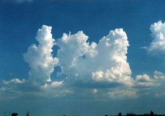
Above: Cumulus Congestus
Cumulus Congestus
Many people would agree that if there is one type of cloud which is interesting to watch, it is the cumulus congestus cloud. Their unique shape attracts people the most.
What are cumulus congestus?
The word cumulus means bunched up and congestus is a Latin word that refers to ‘piled up’. Cumulus congestus clouds are known as towering clouds because they tend to rise upwards with a small base. As they develop further, they transform into cumulonimbus clouds and sometimes carry light rain with them but once they are transformed into cumulonimbus clouds, one can expect thunderstorms, lightening and hail as well.
What height are cumulus congestus clouds found?
The main reason why they are called towering clouds is that they can rise to a great extent with clear outlines. When weather conditions are conducive, they can rise up to 15000 to 20000 ft and the minimum height of these clouds is approximately 2000 ft. Apart from the convection process; atmospheric instability is also required for the formation of these clouds. This happens when a cold air current slides over the cloud and makes the temperature of the surrounding air mass to fall swiftly with height.
How are cumulus congestus clouds formed?
As cumulus mediocrics move upwards and show vertical development, the clouds are named as cumulus congestus clouds. They usually experience strong updrafts and keep moving upwards if the surrounding atmosphere is favorable. It is believed that these clouds are formed later in the day when they experience more vertical movements. As they move upwards, they tend to get thick and show volumetric increase as well; therefore they are thicker than cumulus mediocrics clouds. When climatic conditions are quite stable, that is when there is high pressure that suppresses vertical movements and these clouds usually spread to the sides. As cumulus congestus clouds progress vertically, their top puffs tend to detach themselves from the main cloud. These puffs are carried away by the wind and new clouds are formed.
What do cumulus congestus clouds look like?
They have a dark base and have a gigantic appearance; most noticeable is the huge volume swelling in the air that makes them different from other clouds. The most important thing which makes them stand out from the rest of the clouds is their cauliflower shape from the top. Since they belong to the cumulus group, they do have fluffy cotton-ball type appearance with small bases as compared to its altitude. They do not always have a flat base and sometimes grow without maintaining its flat bottom shape.
How common are cumulus congestus clouds?
Since cumulus congestus clouds fall in the category of low level clouds, they are quite common and can be easily seen especially in the summer season and can bring small rainfall with them as well. In areas like Florida, these clouds bring heavy rainfall in a very short span and exist when the whether conditions are slightly unstable.
Where can I see cumulus congestus clouds?
- Land areas during summer
- Coastal areas during winter
- Usually seen in evenings when the sun is lower.
