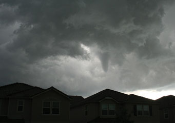
Above: Cumulonimbus Tuba
Cumulonimbus Tuba
Cumulonimbus tuba is a cloud formation where the base of the cumulonimbus cloud, while producing extreme weather conditions such as thunderstorms and heavy showers, takes on a new dimension that can eventually result in tornadoes and whirlwinds.
What are cumulonimbus tuba clouds?
Cumulonimbus tuba clouds form under dark and heavily saturated cumulonimbus clouds that are ready to deposit their rain in the form of heavy showers or thunderstorms. The Cumulonimbus tuba clouds are formed when the air pressure is low and there are a number of different layers of warm and cold air below. The cold air causes the warm air to stop rising and therefore creates a pressure build up. This pressure build-up causes the cloud to literally be sucked down to get access to the warmer moisture below.
What height are cumulonimbus tuba clouds found?
Cumulonimbus tuba clouds reach from the base of the cumulonimbus cloud that is normally at a height of between 1,000 to 2,000 feet to a height that can be no more than 20 feet above ground level. If the Cumulonimbus tuba clouds are formed above water they can cause water spouts that can suck water from the surface of the sea or the lake without actually reaching down to touch it.
Classification of Cumulonimbus tuba clouds
Cumulonimbus tuba clouds are classed in the Cb category a subset of cumulus clouds. Any report of cumulonimbus tuba clouds will be looked at carefully. If the cumulonimbus tuba clouds simply manifest itself during heavy storm, but does not reach the ground or get near it, the cumulonimbus tuba clouds will be considered not threatening.
How are cumulonimbus tuba clouds formed?
Cumulonimbus tuba clouds are formed by strong winds underneath the cumulonimbus cloud formation. If a cumulonimbus cloud forms rapidly there will be a trade off with warm air rising rapidly, while at the same time cooled air drops rapidly towards the ground drawing the cloud with it and form the cumulonimbus tuba clouds.
What do cumulonimbus tuba clouds look like?
Given their name it is quite easy to work out what cumulonimbus tuba clouds look like, however the difference from an interesting weather phenonomen and a potential weather condition that could cause injury or death is important .Therefore it is extremely important to know:
- Over water cumulonimbus tuba clouds are not too dangerous, but if you are boating you should move away from them as soon as possible.
- During August, September and October in the northern hemisphere, cumulonimbus tuba clouds can turn into tornados
- Watch the shape of the cumulonimbus tuba clouds and if they seem to be turning more substantial and twirling faster, prepare to take cover
How common are cumulonimbus tuba clouds?
In Florida and also over the Great Lakes, cumulonimbus tuba clouds are quite common during the summer months from August to October in particular. However they are also particularly prevalent in the Mid West of the United States and also in the Ukraine, where they can cause serious material damage.
Where can I see cumulonimbus tuba clouds?
At ground level is the best place to see cumulonimbus tuba clouds, particularly over warm water where there is no large lake or sea and there should be little wind before the cumulonimbus storm breaks. Any heavy thunderstorm activity can give you a good chance to see them.
