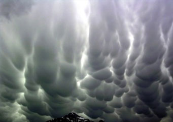
Above: Cumulonimbus Mamma
Cumulonimbus Mamma
Cumulonimbus clouds are the rain or thunderstorm clouds at their excellence. These are the clouds which people who love outdoor activities like to avoid at all costs and that aircraft pilots want to stay clear of. They are tall clouds and are found towering up into the troposphere, whereby their peaks metamorphoses into ice particles, while their bottoms often appear dense and often assume a grayish appearance.
What are cumulonimbus mamma clouds?
These are pouch-like rain clouds that often form after a thunderstorm or just underneath a thunderstorm when cooler air mixes with warmer air just below the storm’s clouds. To some people, cumulonimbus mama clouds resemble the shape of the human female breasts.
The main characteristic of cumulonimbus clouds is that their base is covered by rounded protuberances, which to casual observers look like human breasts, giving their nickname ”mammatus”. These clouds are associated with strong thunderstorms or tornado like activities. Their formation mechanism and their distinctive features (the pouches) is a matter of significant and varied theories.
What are the height of cumulonimbus mamma clouds?
These are thunderstorm clouds that can be formed at a height of below 6000 feet or high as 10 000 feet above the ground in auspicious conditions (low relative humidity and hot air that has been warmed up by the sun).
How are cumulonimbus mamma clouds formed?
These types of clouds form when the cool air meets a parcel of hot and moist air rising from the earth’s surface. They normally develop from cumulus congestus type of clouds that forms at lower heights, and that grow vertically upwards.
The lower levels of these types of clouds consist of mostly water droplets while at higher elevations where the temperatures are below 0 degrees centigrade, these clouds fully comprise of ice crystals.
How common are cumulonimbus mamma clouds?
As any other cumulonimbus clouds, cumulonimbus mamma clouds are quite common the world over, with the exception of the Antarctica region. When cumulonimbus mamma’s pouches appear full, it means a heavy thunderstorm is about to happen. This often means trouble. They are threatening when they occur, as the resultant hailstorm, thunderstorm or snowstorm is often havoc wrecking and should be avoided at all costs. These clouds carry along a heavy baggage that comprise of heavy rain, strong winds, hails and often lighting. This is why aircraft pilots try their best to avoid them. Actually, they can easily destroy the aircraft’s fuselage, while the resultant lightening mainly interferes with a plane’s electronic control systems.
Apart from this, the severe turbulence caused by these clouds makes flying almost impossible and no sane pilot would willingly fly directly into them. From a distance, these clouds look very beautiful and calm but while beneath them, it is different story all together. They may appear to be brightly magnificent at their top, while their bases may be the contrary-quite dense, grayish and unsightly.
Common features of cumulonimbus mamma clouds
- Pouch-like in appearance.
- Are found all over the word, with an exception of Antarctica.
- Causes heavy downpours that are accompanied by strong winds, hails and lots of lightening.
- Quite imposing, intriguing and darkish in appearance.
