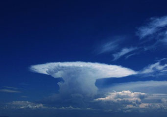
Above: Cumulonimbus Incus
Cumulonimbus Incus
Typically, cumulonimbus clouds produce very heavy downpours, hails, snow showers, thunderstorms, tornadoes and lightening. This is why they are also referred to as thunderstorm or rain clouds by many. Apart from this, they are associated with flash flooding and vertical strong winds that normally causes a lot of havoc when they last. A good example of such clouds is the cumulonimbus incus clouds.
What are cumulonimbus incus clouds?
Also referred to as the king of the clouds, a full-blown cumulonimbus incus cloud is definitely a mountain of a cloud. This moisture mountain is by far as tall as Mount Everest or even more, and often in the tropics and in subtropical regions; it can reach a height of sixty thousand feet above the ground level.
In their full splendor, cumulonimbus incus clouds are caped by a massive wedge-shaped high cloud that resembles a blacksmith’s anvil. Cumulonimbus incus clouds are sometimes called the thunderhead or the hammerhead.
In uncharacteristic cases, the updraft associated with cumulonimbus cloud is so powerful that it passes through the troposphere and carries parcels of clouds into the lower levels of stratosphere, before bouncing back to the troposphere as they loose their momentum. This produces an upward swelling on the otherwise flat upper surface of the thunderhead or the anvil. This is a perfect indicator that a severe storm is on the offering.
How is cumulonimbus incus clouds formed?
As long as the air in the surrounding area remains erratic, the cumulonimbus incus cloud goes on rising and expanding. Eventually, they reach the troposphere layer, where air temperatures actually stabilize and begin to increase with the altitude. The change of weather actually puts a lid on the updraft, thereby stopping the cloud from further rising. Nevertheless, the air up-thrust continues pushing upward forcing the clouds to spread further and in a circular fashion, thereby producing the anvil shape that characterizes this type of a cloud formation. The position of this cloud formation points out the troposphere height in an area.
How do cumulonimbus incus clouds look like?
As these clouds are located above the level by which the air temperatures drop below the freezing point, they are normally made up of ice like crystals that form a peak of cirrus formation above the key cloud’s mass. These ice-like crystals might be blown away or around by powerful winds, thereby forming a streaky-like appearance. Like all other cumulonimbus clouds, they are darkish in appearance due to the fact that they are heavy with water-drops.
Characteristics of cumulonimbus incus
- They can be found all over the world (very common in the tropics) except in the Antarctica region.
- Forms at the height of 2000 feet to 35 000 feet above the earth’s surface.
- There are caused by extra powerful convections that are assisted by atmospheric instabilities.
- They are associated with heavy downpours and powerful winds.
- These are turbulent clouds that produce heavy rains, strong winds, hails, lightening and tornadoes at the ground level. This is very dangerous to aircrafts, especially the small single engine types.
