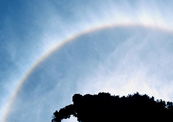
Above: Cirrostratus Nebulosus
Cirrostratus Nebulosus
Cirrostratus are the most common form of cirrostratus clouds and are characterized by a high altitude form of white nebulous cover in which the sun or the moon can be seen with a halo around it.
What are cirrostratus nebulosus clouds?
Cirrostratus nebulosus clouds are high altitude clouds that normally form above 16,000 feet. They are composed of ice crystals that give them their characteristic bright white appearance. Sometimes they can stretch for miles, satellite images have shown cirrostratus nebulosus that stretch across whole continents. Although they appear to move slowly, they can actually be driven by jet streams at speeds of up to 100 mph. This appearance of slow movement compared with other clouds is explained that cumulus clouds are found at an altitude of 2,000 feet and the cirrostratus clouds can be as much as 20,000 feet higher. This explains the apparent perceived difference in speed.
What height are cirrostratus nebulosus clouds found?
Cirrostratus nebulosus clouds can be found at high altitudes above 16,000 feet. Cirrostratus nebulosus clouds are formed by ice crystals and so depending on the season and the location where they will be formed, the ice crystals can form at altitudes of between 16,000 and 30,000 feet.
Classification of cirrostratus nebulosus clouds
Cirrostratus nebulosus clouds are part of the high altitude A class cloud family. Their specific class is Cs and the suffix for this type of cirrostratus cloud is Neb.
How are cirrostratus nebulosus formed?
Cirrostratus nebulosus clouds are formed during periods of fair weather. They are formed basically due to the following conditions:
- Good weather conditions with a steady light wind that allow convergence to cause water particles to rise in the air, collect dust particles and rise into the atmosphere.
- No lower level clouds that can impede these water particles from rising to higher altitudes
- A warm weather front arriving as air pressure drops making the rise of the water droplets easier
What do cirrostratus nebulosus clouds look like?
Cirrostratus nebulosus clouds appear as a veil across the sky like a milky white mantle. These cirrostratus nebulosus clouds can completely cover the sky and give it a totally white appearance.
How common are cirrostratus nebulosus clouds?
They are extremely common and can appear anywhere in the world at any time of the year. They can be formed in one place, for example over the oceans and then be transported hundreds of miles to cover countries and continents far inland. It has been noted that cirrostratus nebulosus clouds can cover a number of large countries; this is helped by the fact that they are not affected by convection from mountain ranges or large stretches of water.
Where can I see cirrostratus nebulosus clouds?
As the most common form of cirrostratus clouds, cirrostratus nebulosus clouds can be observed in any part of the world. Should you see them, they normally give you an advanced warning that bad weather is approaching and will probably arrive within the next 12 to 24 hours. If you check your barometer, you should see that pressure is falling and humidity rising.
