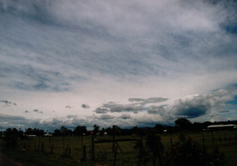
Above: Cirrostratus Duplicatus
Cirrostratus Duplicatus
Cirrostratus duplicatus clouds are a particular form of cirrostratus clouds that are formed at the highest altitudes. They can be the thickest form of cirrostratus clouds and aerial observation has shown that they can be as much as 8 kilometers thick.
What are cirrostratus duplicatus clouds?
Cirrostratus duplicatus clouds are made up of layers of cirrostratus clouds that are divided almost like the layers of a cake. Each layer can be no more than a few hundred meters thick and one layer overlays another. As a result, when viewed from the ground it is possible to see one layer moving in one direction while another moves in a different direction, this effect makes their patterns constantly change and they are interesting to observe.
What height are cirrostratus duplicatus clouds found?
Cirrostratus duplicatus clouds will be found at heights over 16,000 feet in cold climates, but at far higher altitudes over the tropics, as high as 30,000 feet. The cirrostratus clouds are formed of ice crystals so the point at which these can form will dictate the height that the cirrostratus duplicatus clouds can develop. Cirrostratus duplicatus clouds are made up of a number of layers of cirrostratus cloud that are caused by repeated developments of cirrostratus clouds that are separated by winds keeping each layer apart
Classification of cirrostratus duplicatus clouds
Cirrostratus duplicatus clouds, according to the WMO, are a category A cloud, which means that they are found at the highest altitude. Cirrostratus duplicatus clouds are referred to as CS Dup clouds using their full abbreviation.
How are cirrostratus duplicatus formed?
Cirrostratus duplicatus clouds are a particular from of cirrostratus clouds and their formation is different from other cirrostratus clouds for the following reasons:
- They form in the same way as other cirrostratus clouds but their development is interrupted by high speed winds
- Each layer rises into the upper atmosphere but strong crosswinds stop the cirrostratus clouds forming together
- Seen from the ground they can appear exactly as cirrostratus nebulosus clouds, as they do not obstruct the view of the sun or the moon totally, rather they make the sun or moon shine appear milky
- If you fly though them you will notice that the layers undulate and move closer or farther apart, but do not join, thanks to the steady winds blowing between them
What do cirrostratus duplicatus clouds look like?
Cirrostratus duplicatus clouds look exactly the same as cirrostratus nebulosus clouds from the ground but in the air they can be seen to be made up of as many as twelve different layers.
How common are cirrostratus duplicatus clouds?
It is difficult to know exactly how common they are, as from the ground they cannot be differentiated from the more common cirrostratus nebulosus clouds. Weather balloons that are sent up to monitor their composition are unable to differentiate the difference between them because there is no temperature difference.
Where can I see cirrostratus duplicatus clouds?
They can best be seen as a storm front approach, the high winds at upper and lower altitude levels will cause the clouds to be fragmented and therefore the cirrostratus duplicatus clouds to form. From the ground, they will be difficult to pick out.
