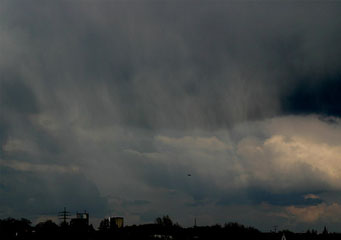
Above: Nimbostratus Virga
Nimbostratus Virga
Nimbostratus clouds are formed at medium level between 6,000 and 20,000 feet, at this height they are categorized as altostratus clouds. If atmospheric conditions permit the cloud to sink to lower levels and nimbostratus clouds can be found at altitudes of between 2,000 to 6,000 feet. What happens next with nimbostratus clouds is that they normally cause rain to fall. Nimbostratus virga clouds are particular in that the rain does not actually reach the ground.
What are nimbostratus virga clouds?
Nimbostratus virga clouds look no different from other forms of nimbostratus clouds with one main difference. When viewed from the ground they appear the same as other nimbostratus clouds, unremarkable and hard to work out any form other than a grey or dark grey slab covering the sky. However the nimbostratus virga clouds can be clearly identified as there appears to be a veil of rain falling from the cloud. On closer inspection this veil clearly does not make it to the ground.
What height are nimbostratus virga clouds found?
Nimbostratus virga clouds are formed in the mid latitude heights between 6,000 and 20,000 feet. Were they to remain there they would be classified as altostratus virga clouds, however as the nimbostratus cloud by nature drop in height they become nimbostratus cloud, but the virga effect is able to continue thanks to the warm conditions.
Classification of nimbostratus clouds
Nimbostratus clouds are D1 clouds that means that they are rain bearing. Specifically they are classified as Ns vir, they are one of the most particular cloud types and occur most often in the coldest winter months or in the hottest summer months.
How are nimbostratus virga clouds formed?
Nimbostratus clouds are formed by the gradual arrival of a warm or occluded front that allows clouds to form gradually. In temperate regions these formations are most likely to occur. Starting to form at higher altitudes the cloud becomes more saturated and begins to descend to the lower levels between 2,000 and 6,000 feet. These clouds become more saturated and begin to cause rain to fall. However with warmer temperatures at the lower ground levels the rain does not actually hit the ground but evaporates and returns to the cloud. In the winter time the same effect causes ice particles to float back upwards to form heavier snowflakes.
What do nimbostratus virga clouds look like?
They appear very similar to nimbostratus clouds but with one particular difference. Nimbostratus clouds are normally lacking in definition and appear as a uniform slab of cloud cover with no distinguishing features. Nimbostratus virga clouds have shoots of rain falling like triangular wedges that are wider at the top, near the base of the cloud that reach a point somewhere above the ground without touching it.
How common are nimbostratus virga clouds?
You will be able to find nimbostratus virga clouds in the following conditions:
- They can be found wherever nimbostratus clouds can form, but the nimbostratus virga effect is relatively rare
- They are most common when the difference in the air temperature where the clouds form and the ground temperature is quite high.
Where can I see nimbostratus virga clouds?
Nimbostratus virga clouds are best seen in the mid west of America, over the prairies and the steppes of Russia. The most likely place is to see them is far away from the sea or ocean currents.
