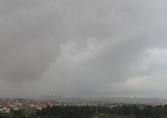
Above: Nimbostratus Pannus
Nimbostratus Pannus
Nimbostratus clouds form at medium level that is between 6,000 and 20,000 feet but in order to be categorized as nimbostratus clouds. Once they form they can develop in to various different types. Nimbostratus clouds normally bring in grey or dark grey cloud cover with associated drizzle or steady light rain, Nimbostratus virga cloud brings downpours that actually don't reach the ground as the rainfall evaporates before it reaches the ground and evaporates back upward into the cloud.
What are nimbostratus pannus clouds?
Nimbostratus pannus clouds can be easily identified as they look different from other nimbostratus clouds, they gradually form and take shape as the winds that start to disturb the nimbostratus clouds change their shape and cause the nimbostratus clouds to disperse. As the winds rip into the nimbostratus clouds the nimbostratus pannus clouds start to evolve, they look like tubes of cloud rising from 2,000 feet to higher levels.
What height are nimbostratus pannus clouds found?
Nimbostratus pannus clouds are formed in the lower cloud levels and will gradually grow higher, as pannus clouds they hit mid latitude heights between 6,000 and 20,000 feet. Should they reach these altitudes they could evolve into the more volatile cumulonimbus clouds that bring thunderstorms and flash rainstorms.
Classification of nimbostratus pannus clouds
Nimbostratus pannus clouds are not D1 clouds, this means that they will not normally bring rain. Specifically they are classified as Ns pan; this means that while their formation could cause rain they are really unlikely to do so as their formation indicates good weather ahead.
How are nimbostratus pannus clouds formed?
Nimbostratus pannus clouds are formed in the final stages of the development of nimbostratus cloud formations. What this means is that the nimbostratus clouds are created from the formation of altostratus clouds that, thanks to the weather conditions, causes the cloud formations to fall to lower levels and form nimbostratus clouds. When stronger upwind drafts form, the nimbostratus clouds are disturbed and broken up causing nimbostratus pannus clouds to form.
What do nimbostratus pannus clouds look like?
They look like tubes and are a very welcome sight for the observer. Nimbostratus clouds are essentially flat featureless and essentially boring. Consider that nimbostratus clouds normally cover the sky with a grey blanket that is both grey and depressing, the sight of these clouds signifies that something is developing and the weather may be changing for the better. These clouds have a similar appearance to cumulonimbus clouds and can indicate that a change in the weather is coming.
How common are nimbostratus pannus clouds?
They are very common in the mid and northern United States. Northern and central Europe and even southern countries in South America such as Chile, Uruguay and Argentina. These will often be places where you can observe them:
- If nimbostratus clouds can be formed nimbostratus pannus clouds can be formed
- If you see nimbostratus clouds form there is a good chance that a change of the weather is coming sooner or later
- Nimbostratus pannus clouds can indicate that bad weather is coming if they turn to cumulonimbus clouds.
Where can I see nimbostratus pannus clouds?
The best time to see them is when the sky is covered with nimbostratus clouds and the barometer is falling, the cloud will start to get ripped up by stronger winds and nimbostratus pannus clouds will form.
