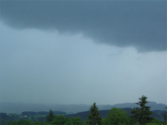
Above: Nimbostratus Praecipitatio
Nimbostratus Praecipitatio
The nimbostratus praecipitatio is a cross type cloud formation, usually developing in the lower parts of the atmosphere. While the nimbostratus classification refers to a spread out cloud or a shapeless structure, the praecipitatio taxonomy suggests that these patterns are often associated with rain or snow that reaches the ground. The nimbostratus name is composed of the "nimbo" prefix that denotes a cloud structure that brings precipitation, and "stratus" that is an indicator of their form. In addition, the praecipitatio cataloging is commonly used to suggest an adjacent cloud mass, which is undersized and located just underneath the main cloud.
How are nimbostratus praecipitatio clouds formed?
It is important to note that these cloud structures are included in the low level clouds category, which means that they form at an altitude of below three thousand meters in the atmosphere. These cloud patterns are common for the temperate climates and are usually formed due to the circulation of warm air fronts. More exactly, the warm air that rises from the surface of the earth will be lifted and constantly cooled. However, the dew point of most nimbostratus formation is usually above the freezing point. Consequentially, these clouds are composed of water droplets. On a side note, nimbostratus patterns can also develop when altostratus clouds become too thick and heavy and fall to lower altitudes.
What do nimbostratus praecipitatio clouds look like?
As mentioned before, these cloud structures do not have a specific and distinctive shape. In fact, the easiest way to describe them is a sheet which a dark tone coloration. Their color suggests the fact that they have high amounts of moisture. In fact, the darker their shade, the more humidity they incorporate. The length that these formations can spread varies a lot. Therefore, sometimes they can spread through the entire sky and cover the horizon.
The praecipitatio associated formation further adds to the appearance of the clouds. Therefore, besides the grey shade spreading, sky gazers can identify nimbostratus praecipitatio clouds by the curtain or rain that is often seen at the horizon or far away. Overall, they may appear very similar to the cumulonimbus praecipitatio clouds, especially when they cover the entire sky. However, here is what distinguishes the nimbostratus formations from the cumulonimbus structures:
- They will generally bring heavier precipitation
- They are not accompanied by thunder or lightning
- Will generally last longer and are constant
How common are the nimbostratus praecipitatio clouds?
Whilst it is true that they can form almost anywhere around the globe, as all they require is fronts of warm air, in general they are specific for the temperate continental and oceanic climates. However, it is important to note that not all regions allow this process to go smoothly. For instance, in the Appalachian Mountain chain in North America, meteorologists observe a rare and unique phenomenon known as cold air damming. Therefore, since the fronts of hot air are advancing and getting cooled rather slow in comparison to the other geographical regions, the precipitations there last for several days and even a week.
