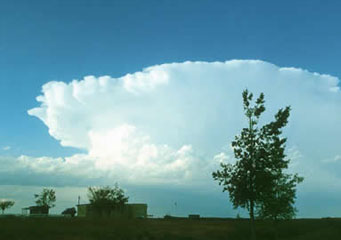
Above: Cumulonimbus Clouds
Cumulonimbus Clouds
Oftentimes, many different clouds are referred to as rain clouds. But the cumulonimbus cloud is the real rain cloud – or storm cloud more likely than not. These clouds have a very threatening appearance, and often back up that threat with storms. These can even be very dangerous, because one subtype of this cloud is the type that begins a tornado.
What are cumulonimbus clouds?
Cumulonimbus clouds are storm clouds. More specifically, they are large, looming clouds that are incredibly tall and dense. They always produce some sort of precipitation, though the specific type depends on the species of cumulonimbus cloud that is present in the sky.
What height are cumulonimbus clouds found?
Cumulonimbus clouds have a very significant location – everywhere. These clouds can literally run through all three regions of the atmosphere because they are just that big. They usually start fairly low with a base as low as 5,000 feet. They often go up to 20,000 feet in the sky. But, in more extreme cases, they can even top 50,000 feet easily.
Types of cumulonimbus clouds
This is actually a general type of cloud. There are several species in this cloud type which include:
- Cumulonimbus praecipitatio
- Cumulonimbus calvus
- Cumulonimbus pannus
- Cumulonimbus velum
- Cumulonimbus capillatus
- Cumulonimbus mamma
- Cumulonimbus arcus
- Cumulonimbus incus
- Cumulonimbus pileus
- Cumulonimbus tuba
- Cumulonimbus virga
How are cumulonimbus calvus clouds formed?
When the air becomes unstable and cool air begins to move, an updraft or downdraft is created. This creates the perfect atmosphere for the formation of a storm. And this is where these particular clouds begin to form and grow. They can even sometimes grow so large that a supercell storm cloud is formed, which can lead to many large tornadoes.
What do cumulonimbus calvus look like?
These clouds have a significant appearance for the most part. They are usually gigantic, looming and dark. They often have a significant mushroom like shape that is very recognizable later in the storm. It can even have an anvil like top that is very significant.
How common are cumulonimbus calvus clouds?
Actually in general, cumulonimbus clouds are a very common type of clouds. They usually bring storms, and especially throughout the spring, storms are very common. Some specific types of these clouds though, are much less common and this includes the cumulonimbus calvus. Other types in the cumulonimbus family are seen every single time there is a storm.
Where can I see cumulonimbus calvus clouds?
If you are looking for a cumulonimbus cloud, you literally don’t have to look very hard at all. All you have to do is wait until the air begins to cool down in anticipation of a storm. You will see some types of these clouds in the very beginning of the storm, even before it rains. Some will last, and some will fade very quickly. As the storm progresses, depending on how strong it is, you can see other types of these clouds. Just don’t wait too long to see them all if the weather is too bad.
