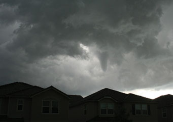
Above: Cumulonimbus Tuba
Cumulonimbus Tuba
Cumulonimbus tuba clouds are distinctive as they have a kind of tower or column that links to the main cloud base and hangs down but does not reach the ground. It can sometimes look like a funnel and give a false assumption of the cloud turning into a tornado. Sometimes the funnels will touch the ground and this will then be classified as a tornado.
What height are cumulonimbus tuba clouds found?
Cumulonimbus tuba clouds are another variety of cloud that is formed at a low level in the atmosphere. That means it is rarely found above 6,000 feet. The tuba can be attached to other types of clouds too, but these will go no higher than the middle level in the air, or around 20,000 feet.
Classification of cumulonimbus tuba clouds
Cumulonimbus clouds can have lots of different species within their classification, of which tuba is only one. The Latin words used to classify the different cloud types remain in force and although some of the cloud structures may appear similar they have different names depending on the accessory clouds or conditions in which they were formed.
How are cumulonimbus tuba clouds formed?
The tuba, that is a funnel of cloud that descends from the cumulonimbus clouds, is produced when there is a column of wind rotating around the cloud. The cloud is filled with water droplets, as most other clouds are. The tuba, or funnel cloud, is distinctive in appearance and although many of these are dissipated when the water is released, some will turn into tornadoes once the funnel touches the ground. In order for a tuba cloud to turn into a tornado the following conditions must be met:
- Cold air meets warm air to cause atmospheric instability in the cloud
- A drop in pressure within the cumulonimbus cloud creates a funnel or cone shape to drop from the cloud base
- The funnel-shaped cloud must touch the ground to become a tornado
Although many tuba formations can be seen in the sky many of them do not develop into tornados as the rain, hail or snow falls before the tuba shape touches the ground.
What do cumulonimbus tuba clouds look like?
Cumulonimbus tuba clouds are easy to see. The thick fluffy grayish clouds form the cumulonimbus clouds and these are accompanied by a discernible funnel reaching down towards, but not touching, the earth.
How common are cumulonimbus tuba clouds?
Cumulonimbus tuba clouds can be commonly seen in America as well as other regions around the world. As there are certain parts of America that are prone to supercell storms and tornadoes, then these types of clouds are usually present. Cyclone-type activity is more common in the springtime as the warming air current produces the right atmospheric conditions to create the storm clouds.
Where can I see cumulonimbus tuba clouds?
America has the highest incidence of tornadoes, although it is not the only area in the world associated with them. Geography plays a huge part in creating cumulonimbus tuba clouds and the USA has the right kind of structures to promote a thriving climate for tornadoes. Other parts of the world will also witness cumulonimbus tuba clouds that remain in the same state and do not change to tornadoes.
