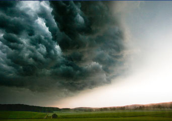
Above: Cumulonimbus Arcus
Cumulonimbus Arcus
Cumulonimbus clouds are basically storm clouds. They can give rain, hail or snow and are usually very thick and heavy looking. They produce dramatic downpours and quickly dispel their load. They can stretch as far as 10 miles, so this gives an indication of why they are considered to be the king of the clouds.
What height are cumulonimbus arcus clouds found?
Stratocumulus clouds are low level clouds and arcus clouds are also seen at a low level in the sky. Therefore, the height of these kinds of clouds can be anything up to around 2,000 meters.
Classification of cumulonimbus arcus clouds
Arcus clouds are a type of cloud formation that is low in the sky and is horizontal. There are two sub categories of this type of cloud:
- Shelf cloud
- Roll cloud
Arcus clouds are generally considered to be a sub type of cloud formation. Shelf clouds are usually attached to one of the main cloud types, including cumulonimbus clouds. Roll clouds are generally unattached to other cloud types and create a dramatic effect when being propelled across the sky in a rolling motion.
How are cumulonimbus arcus clouds formed?
They are formed following as a precursor to a thunderstorm or following a front of cold air stream. The cooler air will tend to sink and spread out. This sinking activity will prevent rising warmer air from being pulled into the storm cloud updraft. The resultant conditions provide the right atmosphere for the clouds to form and they are buffeted by winds, giving them a rolling effect. In order to be formed these clouds need to satisfy three criteria:
- Unstable atmosphere
- Warm moist air rising at a rate of more than 25 miles per hour
- Increase of tropospheric winds
What do cumulonimbus arcus clouds look like?
Cumulonimbus arcus clouds are thick stormy clouds. They can vary in color from deep gray, almost back, to a lighter gray. The roll arcus clouds can often be seen at the leading edge of thunderstorm clouds. These are dark brooding clouds and once you see them you can be sure you are in for a real storm. As dramatic as they are there is something a little foreboding about them.
How common are cumulonimbus arcus clouds?
Cumulonimbus arcus clouds are quite common in tropical areas, as they require a good supply of warm, moist air that rises quickly into the atmosphere to enable them to form. These kinds of clouds are not caused by temperature inversions and so if the air is unstable and satisfies the criteria then you will have cumulonimbus arcus clouds forming.
Where can I see cumulonimbus arcus clouds?
One of the most famous cumulonimbus arcus clouds was seen over Australia and has been named Morning Glory. It is spectacular in appearance. Cumulonimbus arcus clouds also appear in areas with temperate climates and the tropical regions too. Not only do cumulonimbus arcus clouds pour down rain, they also shed hail and snow too, although they are rarely seen at either the North Pole or the South Pole.
