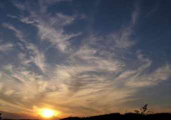
Above: Cirrus Duplicatus
Cirrus Duplicatus
Hardly a day passes by without some form of cirrus clouds being spotted high up in the sky. In winter, cirrus clouds are still common, though they may be obscured by low cloud cover. Cirrus clouds come in numerous sub-forms; for instance, cirrus duplicatus.
What are cirrus duplicatus?
These are a sub-form of cirrus clouds and form in at least two layers, in most cases they occur in duplicate form. These cirrus clouds are normally arranged in interwoven layers, though at different levels and sometimes are merged in some places. Generally, these clouds are thin enough as to be transparent, or if not, very close to it. As with all cirrus clouds, they form in fair weather and if they thicken it is a good indicator that a storm is forthcoming.
What height are cirrus duplicatus clouds?
Cirrus duplicatus clouds usually form well above the 16 000 feet level mark above the earth’s surface. Often, they are comprised of streaking strips of ice crystals that normally enhances their appearance. Cirrus duplicatus cloud layers or sheets are normally interlinked and the stratified parts are sometimes partly merged at slightly different levels.
How are cirrus duplicatus clouds formed?
Like aforementioned above, cirrus duplicatus clouds are primarily composed of ice crystals. These clouds form when warmer ground air finally meets with colder air from the atmosphere or on higher altitudes. As the sun’s heat continues to warm up the ground, bubbles of hot air (thermals) continue to rise upwards from the warm surface. These thermals or hot air bubbles undergo convection. When the cool air up there dominates the warm air or the thermals, moisture from the troposphere condenses and forms the clouds.
Due to the high altitudes they are formed in, these clouds are often difficult to study. However, some people are of the opinion that they don’t affect the day to day weather situation and that their precipitation does not reach the ground level. This is because it evaporates even before it could reach the earth’s atmosphere due to the high altitudes they are to be found. Depending on the shape and size of ice crystals contained, some people believe that they play a big role in either slowing or speeding up global warming.
How common are cirrus duplicatus clouds?
Cirrus duplicatus clouds are very rare and amazing to observe, they assume their appearance due to various reasons, one of them being the wind’s activities. Because they are formed in extremely low temperatures, the water vapor condenses into ice directly. Furthermore, because of the sparse moisture at such altitudes, they tend to be quite thin and wispy in appearance.
These types of clouds often move from the west to the east across the skies and generally move into the direction of the fairer weather.
Characteristic of cirrus duplicatus clouds
- Appear in double translucent sheets or layers.
- High altitude clouds, meaning they are formed in altitudes of over 16 000 feet above the earth’s surface.
- If the conditions are right, they can occur anywhere in the world.
- Rare, but when they form, they are amazing to look at.
- Fair weather clouds that form very high in the skies.
