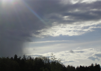
Above: Altostratus Virga
Altostratus Virga
Altostratus virga refers to a common type of cloud. The defining feature of this type of cloud is that it normally has strips of cloud dropping off at the site. This is normally due to the fact that some of the precipitation within the cloud may not reach the ground after it's released from the cloud. This is then visible as wisps of clouds that seem to reach to the ground when viewed from afar, but which in essence don't.
What height are altostratus virga clouds found?
Altostratus virga, being altostratus clouds, are normally formed at a medium height when compared to other types of clouds. This equates to around 6,000 to 23,000 feet above sea level, or 2,000 to 7,000m. This altitude is the altitude at which most altostratus clouds are formed, and is one of the defining features of the genus.
Classification of altostratus virga clouds
Clouds are normally classified into different genera (plural of genus) depending on the altitude at which they form. This is one of the commonest classification methods, though others exist. According to this, the altostratus virga would be termed middle clouds, since they form at an average distance above sea level.
How are altostratus virga clouds formed?
Altostratus virga clouds are formed when moisture-laden water is carried up to a desired altitude, at which point it condenses to form the cloud. This means that for these clouds to form, air (in the form of wind) first has to collect moisture. This is normally the case when the wind flows over a water body such as an ocean, picking up water molecules. When the water-laden wind meets with cold, heavy wind, it’s normally pushed upward. Since the temperatures in the upper atmosphere are much lower than down below, the water contained within the clouds is usually condensed which forms the cloud. Further condensation beyond a certain critical point yields rain.
For these clouds to form, therefore, several conditions have to be met:
- The air has to contain a reasonable amount of moisture. It shouldn’t be too much, or it could end up forming heaver clouds.
- The air has to have a way of being pushed to the upper atmosphere. This could either be through interaction with another air mass, or simply the presence of a mountain which causes the air to have its direction changed upward.
What do altostratus virga clouds look like?
Altostratus virga are characterized by the presence of wisps of clouds curving away from the main body of the cloud, moving downward. However, they normally don’t reach the ground; these wisps terminate at a point between the cloud and the ground.
How common are altostratus virga clouds?
Altostratus virga can be seen in any climate which contains moderate amounts of humidity.
Where can I see altostratus virga clouds?
Altostratus virga clouds can be seen in any environment which has neither too little nor too much humidity. This means that you are unlikely to see them in areas close to a large water body, as in these areas the water is usually too humid and forms heavier clouds.
