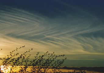
Above: Altostratus Duplicatus
Altostratus Duplicatus
In general, altostratus clouds cover a large portion of the skies and are often in the motion. As the coverage area increases, widespread precipitation is to be expected in such an area. Altostratus clouds can be categorized into several other sub-categories, mainly due to how they look like, shape and texture.
What are altostratus duplicatus clouds?
Altostratus duplicatus clouds look like sheets or patches of varied layers in the skies and which are sometimes connected at one point or another. Altostratus duplicatus clouds are known to produce light rains or snow falls in a slow unstopping manner.
How are altostratus duplicatus clouds formed?
Altostratus duplicatus clouds are mostly made up of large amount of tiny ices crystals, dust particles and millions of tiny water droplets that are formed when the warm air from the earth’s surface meets with mobile cold air up there in the skies. This type of moisture condenses around minute particles of salt, dirt, ash or even dust in the air. These solidified tiny particles are then turned into tiny ice crystals or million of tiny water droplets that hang suspended in the sky. As more and more tiny crystals or water droplets join them, they becomes visible to the naked eye as clouds.
Water has this unique capability- the ability to become liquid, then be solidified under the right conditions, and then thaw back into its liquid form, forming droplets which later are then visible as the clouds in the skies. As these gathered droplets and ice crystals continue to form, they get bigger and bigger, later falls back to earth as snow, rain or sleet. As this is happening, these clouds are blown here and there by the wind and over long distances making them assume their shape. Altostratus duplicatus get their texture and shape this way. As the wind blows the normal altostratus clouds here and there, they are torn into layers which appear above each other and which are sometimes interconnected at one end.
What height are altostratus duplicatus clouds found?
Like any other altostratus clouds, altostratus duplicatus clouds normally form in altitudes of 2000 meters to 7000 meters above the ground level. They are mostly comprised of both tiny water droplets and million of small ice crystals. They are blue-grayish in color and generally cover a wide area in the skies. The sun and the moon are clearly visible through this type of a cloud.
How common are altostratus duplicatus clouds?
Just before a storm, these types of clouds are quite common and they produce a continuous sort of rainfall or snowfall. They are also common in areas that have large masses of water near them and generally occur all the over the world.
Features of altostratus duplicatus clouds
- They are mid level clouds that form in altitudes of 2000 meters to 7000 meters above the ground level.
- They form in layers or patches that are sometimes interconnected at one end but at slightly different levels.
- They form just before the occurrence of a storm and produces a steady continues rainfall or snowfall when they finally break.
- They are a variety of altostratus clouds.
- These clouds are blue-grayish in color and they can cover a large area when they form.
