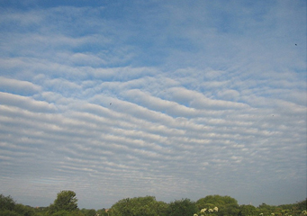
Above: Altostratus Radiatus
Altostratus Radiatus
So you want to take an amazing photo of an altostratus cloud? Well, according to the experts, the best time to go for a search of a beautiful altostratus cloud photo is either late in the day or at sunrise. And unless it is stormy, overcast or at midday, you will surely get a superb photograph of these amazing heavenly wonders. They are varied types of altostratus clouds and that are classified according to their appearance. A good example of such clouds is the altostratus radiatus clouds.
What are altostratus radiatus clouds?
They are a type of altostratus clouds that form low to the ground, but higher than the nimbostratus clouds. Actually, those clouds that are formed below 6000 feet above the ground are stratus type of clouds. And because they form quite high in the skies, altostratus clouds are quite boring to look at. However, these types of clouds are known to produce some light continuous rain or snow falls.
What height are altostratus radiatus clouds found?
Similar to other altostratus clouds, altostratus clouds are found in altitudes of 2000 meter to 7000 meters above the ground. As a result of this, they are referred to as middle level clouds. Furthermore, these types of clouds are blue-grayish in color and often appear just before sunrise and are often an indicator of a probable continuous rainfall or snowfall in the afternoon.
How are altostratus radiatus clouds formed?
Altostratus radiatus clouds are formed as a result of thickening of cirrostratus clouds, or sometimes are formed as a result of thinning of a layer of nimbostratus cloud. They may also develop from such other clouds as altocumulus layer. If this happens, then there is a widespread ice crystal trails or virga fall. In the tropics, altostratus radiatus clouds are formed by the thinning of a part of a cumulonimbus cloud.
What do altostratus clouds look like?
Altostratus radiatus clouds are always on the move and are grayish in color. They have parallel stripes which appear to converge on the horizons. They appear uniformly all over the skies and because they are high enough, both the sun and the moon are able to penetrate through them.
However, due to its composition, the sun or the moon may appear dimmed, though visible. When they form near the earth’s surface, they are quite dark, so the sun and the moon are completely hidden from view.
Generally speaking, snowflakes and water droplets are usually present in all altostratus radiatus clouds, especially its base. The top comprise of billions of solidified ice crystals. When this type of a cloud becomes too heavy with water droplets and ice crystals, it falls down as ice pellets, snowflakes and rain. Basically, when the precipitation reaches the ground, it does so in a continuous manner for some duration of time.
Characteristics of altostratus radiatus clouds
- These amazing fluffy clouds form in broad parallel stripes that appear to converge at the horizons.
- They form in attitudes of 2000 meters to 7000 meters above the ground level.
- They comprise of billions of tiny water droplets and ice crystals.
- They are found all over the world, especially in areas that have large masses of water or that are mountainous.
