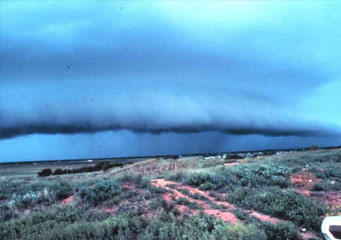
Above: Shelf Clouds
- Home
- Types of Clouds
- Accessory Clouds
- Altocumulus Castellanus Clouds
- Altocumulus Clouds
- Altostratus Clouds
- Anvil Clouds
- Anvil Dome Clouds
- Anvil Rollover Clouds
- Arcus Clouds
- Backsheared Anvil Clouds
- Cirrocumulus Clouds
- Cirrostratus Clouds
- Cirrus Clouds
- Clear Slot Clouds
- Cloud Tags Clouds
- Collar Clouds
- Condensation Funnel Clouds
- Congestus Clouds
- Cumulogenitus Clouds
- Cumulonimbogenitus Clouds
- Cumulonimbus Clouds
- Cumulus Clouds
- Debris Clouds
- Dry Slot Clouds
- Duplicatus Clouds
- Fallstreak Hole Clouds
- Funnel Clouds
- Hail Fog Clouds
- Hot Tower Clouds
- Incus Clouds
- Inflow Band Clouds
- Intortus Clouds
- Inverted Cumulus Clouds
- Knuckles Clouds
- Lacunosus Clouds
- Mammatus Clouds
- Nacreous Clouds
- Nimbostratus Clouds
- Noctilucent Clouds
- Opacus Clouds
- Pannus Clouds
- Perlucidus Clouds
- Pileus Clouds
- Praecipitatio Clouds
- Pyrocumulus Clouds
- Radiatus Clouds
- Roll Clouds
- Rope Clouds
- Scud Clouds
- Shelf Clouds
- Species Fractus Clouds
- Stratocumulus Clouds
- Stratus Clouds
- Striations Clouds
- Tail Clouds
- Towering Cumulus Clouds
- Translucidus Clouds
- Tuba Clouds
- Undulatus Clouds
- Velum Clouds
- Vertebratus Clouds
- Wall Clouds
Shelf Clouds
Understanding cloud formations will help you prepare for the upcoming weather. Let us consider shelf clouds. Have you seen them before? If not, then this is because this cloud formation rarely occurs. So, how does a shelf cloud appear? What does it look like? What type of weather does it bring? If you want to learn more, read further.
Shelf cloud is a type of arcus accessory cloud occurring in wedge-shape form. These clouds are generated as a result of the spreading out of the thunderstorm’s outflow and the rise of warm, moist air into the atmosphere. They are often accompanied by gust front and sometimes roll clouds. A shelf cloud looks like a big lenticularis cloud. This cloud is often mistaken as wall cloud but they are not the same. Whereas wall clouds appear on the backside of a thunderstorm, shelf clouds on the other hand are seen on the leading edge of the thunderstorm. What's more, this cloud formation does not spawn tornadoes because tornadoes are associated with inflow while shelf cloud involves outflow. Even so, destructive winds can be expected to be generated from the thunderstorm most especially if the shelf cloud appears on the gust front of the thunderstorm.
At What Height is Shelf Clouds Found?
Shelf clouds are low-lying clouds, therefore, they can be found at lower cloud elevations at about 6,000 feet from the ground. If a shelf cloud is located near the ground and coupled by rotating heaps of scud clouds, rising dust or vortices on the edge, it strongly signifies that the advancing wind squall is potentially strong.
How do Shelf Clouds Form?
A shelf cloud comes in to being when warm and moist air rises on the leading edge of the gust front of a severe thunderstorm especially when the air near the thunderstorm’s base is very stable. As rain falls to the ground, it carries with it cool air from the thunderstorm’s outflow. Once precipitation drops to the Earth, the cold air spreads out all over the surface. The dispersal of cool air forces the warm, moist air to rise because it is less dense than cool air. So when warm, moist air rises upwards, it cools and condenses forming the shelf cloud.
What do Shelf Clouds Look Like?
This cloud formation exhibits a wedge-shaped appearance. The front edge appears smooth, either terraced or layered; while the bottom portion appears wind-torn. The striations on the bottom side of the cloud are visual evidences of wind shear. While a roll cloud is detached from the base of a thunderstorm cloud, a shelf cloud is attached to it.
How common are Shelf Clouds?
These clouds are common in the middle latitude regions where cold air collides with warm air making the atmosphere favorable for thunderstorm formation especially when the advancing wind squall is extremely strong.
If you take time observing the clouds especially when a strong thunderstorm is developing, you will surely be lucky enough to see shelf clouds forming up in the sky.
